The Philippines is an archipelago comprising 7,107 islands with a total land area of 300,000 km2. The 11 largest islands contain 94% of the total land area. The largest of these islands is Luzon at about 105,000 km2. The next largest island is Mindanao at about 95,000 km2. The archipelago is around 800 km from the Asian mainland and is located between Taiwan and Borneo.
The islands are divided into three groups: Luzon, Visayas, and Mindanao. The Luzon islands include Luzon Island itself, Palawan, Mindoro, Marinduque, Masbate and Batanes Islands. The Visayas is the group of islands in the central Philippines, the largest of which are: Panay, Negros, Cebu, Bohol, Leyte and Samar. The Mindanao islands include Mindanao itself, plus the Sulu Archipelago, composed primarily of Basilan, Sulu Island, and Tawi-Tawi
Physical setting
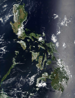
Physical map of the Philippines
The Philippine archipelago lies in Southeast Asia in a position that has led to its becoming a cultural crossroads - a place where Malays, Hindus, Arabs, Chinese, Spaniards, Americans, and others had interacted to forge a unique cultural and racial blend. The archipelago numbers some 7,107 islands; and the nation claims an exclusive economic zone (EEZ) of 200 nautical miles (370 km) from its shores. The Philippines occupies an area that stretches for 1,850 kilometers from about the fifth to the twentieth parallels north latitude. The total land area is slightly more than 300,000 square kilometers. Only approximately 1,000 of its islands are populated, and fewer than one-half of these are larger than 2.5 square kilometers. Eleven islands make up 95 percent of the Philippine landmass, and two of these — Luzon and Mindanao — measure 105,000 and 95,000 square kilometers, respectively. They, together with the cluster of islands in Visayas in between them, represent the three principal regions of the archipelago that are identified by the three stars on the Philippine flag. Topographically, the Philippines is broken up by the sea, which gives it one of the longest coastlines of any nation in the world.
Off the coast of eastern Mindanao is the Philippine Trench, which descends to a depth of 10,430 meters. The Philippines is part of a western Pacific arc system characterized by active volcanoes. Among the most notable peaks are Mount Mayon near Legazpi City, Taal Volcano south of Manila, and Mount Apo in Mindanao. All of the Philippine islands are prone to earthquakes. The northern Luzon highlands, or Cordillera Central, rise to between 2,500 and 2,750 meters, and, together with the Sierra Madre in the northeastern portion of Luzon and the mountains of Mindanao, boast rain forests that provide refuge for numerous upland tribal groups. The rain forests also offer prime habitat for more than 500 species of birds, including the Philippine eagle (or monkey-eating eagle), some 800 species of orchids, and some 8,500 species of flowering plants.
The country's most extensive river systems are the Pulangi River, which flows into the Mindanao River (Rio Grande de Mindanao); the Agusan, in Mindanao which flows north into the Mindanao Sea; the Cagayan in northern Luzon; and the Pampanga, which flows south from east Central Luzon into Manila Bay. Laguna de Bay, east of Manila Bay, is the largest freshwater lake in the Philippines. Several rivers have been harnessed for hydroelectric power.
To protect the country's biological resources, the government has taken a first step of preparing a Biodiversity Action Plan to address conservation of threatened species.
ClimateThe Philippines has a tropical wet climate dominated by a rainy season and a dry season. The summer monsoon brings heavy rains to most of the archipelago from May to October, whereas the winter monsoon brings cooler and drier air from December to February. Manila and most of the lowland areas are hot and dusty from March to May. Even at this time, however, temperatures rarely rise above37 °C (98.6 °F). Mean annual sea-level temperatures rarely fall below 27 °C (80.6 °F). Annual rainfall measures as much as 5,000 millimeters (196.9 in) in the mountainous east coast section of the country, but less than 1,000 millimeters (39.4 in) in some of the sheltered valleys.
Monsoon rains, although hard and drenching, are not normally associated with high winds and waves. But the Philippines sit astride the typhoon belt, and it suffers an annual onslaught of dangerous storms from July through October. These are especially hazardous for northern and eastern Luzon and the Bicol and Eastern Visayas regions, but Manila gets devastated periodically as well.
In the last decade, the Philippines has been hit severely by natural disasters. In 2005 alone, Central Luzon was hit by both a drought, which sharply curtailed hydroelectric power, and by a typhoon that flooded practically all of low-lying Manila's streets. Still more damaging was the 1990 earthquake that devastated a wide area in Luzon, including Baguio and other northern areas. The city of Cebu and nearby areas were struck by a typhoon that killed more than a hundred people, sank vessels, destroyed part of the sugar crop, and cut off water and electricity for several days. The Philippines is prone to about 18-21 typhoons per year. Of course the 1991 Mount Pinatubo eruption also damaged much of Central Luzon, the lahar burying towns and farmland, and the ashes affecting global temperatures.
Building construction is undertaken with natural disasters in mind. Most rural housing has consisted of nipa huts that are easily damaged but are inexpensive and easy to replace. Most urban buildings are steel and concrete structures designed (not always successfully) to resist both typhoons and earthquakes. Damage is still significant, however, and many people are displaced each year by typhoons, earthquakes, and other natural disasters. In 1987 alone the Department of Social Welfare and Development helped 2.4 million victims of natural disasters.
Terrain
The islands are volcanic in origin, being part of the Pacific Ring of Fire, and are mostly mountainous. The highest point in the country is the peak of Mount Apo in Mindanao, which is 2,954 m above sea level. The second highest point can be found on Luzon at Mount Pulog, a peak 2,842 m above sea level.
The Philippine Archipelago is geologically part of the Philippine Mobile Belt located between the Philippine Sea Plate, the South China Sea Basin of the Eurasian Plate, and the Sunda Plate. ThePhilippine Trench (also called the Mindanao Trench) is a 1,320-kilometer-long submarine trench found directly east of the Philippine Mobile Belt and is the result of a collision of tectonic plates. The Philippine Sea Plate is subducting under the Philippine Mobile Belt at the rate of about 16 cm per year. Its deepest point, the Galathea Depth, has a depth of 10,540 meters (5,763 fathoms or 34,580 feet). The Philippine Fault System consists of a series of seismic faults that produce several earthquakes per year, most of which are not felt.
Many volcanoes in the country are active, the most recent eruption being that of Mount Pinatubo on Luzon in 1991. Mount Mayon is another of the active volcanoes and has the world's most perfectly-shaped cone. Mayon has a violent history of 47 eruptions since 1616 and another violent eruption is currently feared. Taal Volcano, also located on Luzon, is one of the Decade Volcanoes.
The islands typically have narrow coastal plains and numerous swift-running streams. Every island has sand beaches, but few open onto spacious lowlands. There are few large plains or navigable rivers. The longest river is the Cagayan River or Rio Grande de Cagayan in northern Luzon measuring 354 kilometers. In Mindanao, the longest river is the Mindanao River or Rio Grande de Mindanao which drainsMaguindanao and other parts in western-central Mindanao. Agusan River drains eastern Mindanao.
Most of the islands used to be covered by tropical rainforests. However, illegal logging has reduced forest cover to less than 10% of the total land area.
The Batanes And Babuyan
Batanes and Babuyan Islands are found on the Luzon Strait north of the Philippines facing Taiwan. It contains the northernmost point of land, the islet of Y'Ami in the Batanes Islands, separated from Taiwan by the Bashi Channel (c.50 mi/80 km wide).
Western Luzon
This region stretches from Mairaira Point in Pagudpud, Ilocos Norte in the north to Cochinos Point in Mariveles, Bataan in the south. The terrain ranges from coastal plains to rugged mountains bordered by the South China Sea in the west and the Cordillera Central and Zambales mountain ranges in the east. Western Luzon is known for its beaches, surf spots and historic towns.
Cagayan Valley
Cagayan Valley (Lambak ng Cagayan in Filipino; Tana' nak Cagayan in the Ibanag language; Tanap ti Cagayan in the Ilocano language) is a region of the Philippines, also designated as Region II or Region 02. It is composed of five provinces, namely: Batanes with Basco as the capital, Cagayan, Tuguegarao City as the capital, Isabela considered to be the heart of the region with Ilagan as the capital, Nueva Vizcaya with Bayombong as the capital, and Quirino with Cabaruguis as the capital. It has three cities; Cauayan City in Isabela, its regional center-Tuguegarao in Cagayan, and its commercial center-Santiago City in Isabela.
Most of the region lies in a large valley in northeastern Luzon, between the Cordilleras and the Sierra Madre mountain ranges. The Cagayan River, the country's longest river runs through its center and flows out to Luzon Strait in the north, in the town of Aparri, Cagayan. The Babuyan and Batanes island groups that lie in the Luzon Strait also belong to the region.
Cordillera Administrative Region
The Cordilleras and Caraballos, together with the Sierra Madre Range, form the main mountain system in Northern Luzon.
The Cordilleras consists of 2, sometimes 3, mountain ranges that are found in northwestern central Luzon. The first, called Caraballo del Sur, forms the nucleus of the system and has its highest peaks in the border between the provinces of Abra, Ilocos Norte and Cagayan. The next, called Caraballo Occidentalles, is further divided into 2 ranges, the Cordillera Norte and Cordillera Central. They line the central portions of the Cordillera Administrative Region.
The Caraballos (Caraballo de Baler) start where the Sierra Madre and the Cordilleras meet. They are found south of Cagayan Valley, northeast of the Central Luzon Plains.
Sierra Madre range
The Sierra Madre range is the longest mountain range in the Philippines and lies in the Northeastern part of Luzon Island. The range stretches from Quezon Province to Isabela. 80 percent of the mountain range is tropical rainforest, which is diminishing from rampant illegal logging activity. Only 5 percent of the mountain range is unexplored. The Sierra Madre Mountain Range serves as the eastern wall of Luzon Island that protects inhibitants from tropical cyclones usually coming from the Pacific Ocean. These storms happen an average of 26 per year will cause a lot of distress for the people living in the biggest island of the Philippines.
Central Luzon plains
The largest plain in the country and produces most of the country's rice supply, earning itself the nickname "Rice Bowl of the Philippines". Its provinces are: Aurora, Bataan, Bulacan, Nueva Ecija, Pampanga, Tarlac, and Zambales. It is an administrative division or region of the Republic of the Philippines, primarily serve to organize the 7 provinces of the vast central plain of the island of Luzon (the largest island), for administrative convenience
Manila Calabarzon plains
This region is where the capital of the Philippines is located. Large rivers from bays and mountain springs traverse the plain. In the Northern part of the region, that is, Manila and Rizal, most of the plain has been converted into cities, and are thus industrialized. The plain harbors the largest inland freshwater lake in Southeast Asia, the Laguna de Bay.
Mindoro island
Mindoro coastal plainsMindoro's coastal plains are characterized by rice and corn fields, rivers, beaches, and extensive open space areas. Most of the population is concentrated on the northern and eastern coast of this island where Calapan and Puerto Galera are located.
Mindoro highlands
The Mindoro mountain range begins with Mount Halcon and is further divided into 3. The northwest ends at Calavite Point and is a landmark for ships. The east originates from Lake Naujan and the west follows Mindoro Strait.
Palawan
Kalayaan islands (Spratly Islands)The Kalayaan islands are located to the west of Palawan. "Kalayaan" is a Filipino word meaning "freedom". see Spratly islands
Bicol peninsula
This peninsula is connected to mainland Luzon by the isthmus of Tayabas. Provinces occupying Bicol Peninsula are the provinces of Camarines Norte, Camarines Sur, Albay, Sorsogon and the easternmost municipalities of Quezon Province.
